I removed the analyses from the blog as there were too many images and I was concerned the server wouldn’t tolerate the traffic. Have converted them to static html pages and they are up here.
Below are some fun posts I’ve kept on the blog rather than converting to html:
In Which Kubrick Tricks Us Into Not Noticing the Door Which Has Opened
A post on the door that opened in the hall beyond Danny when he tried the door to Room 237 and found it locked.
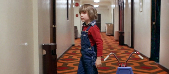
How the Kubrick Carpet Trick Works
A post on how the Kubrick carpet trick works, when the pattern reverses under Danny. So simple!
I had thought it fun to study the locations of the shots on the Going-to-the-Sun road in Glacier National Park in particular, and below are posts showing shots from Google Street View of the locations.
Repurposed shots from Google Maps street view pinpointing the locations of the opening shots on Going-to-the-sun-road are in the following posts: St. Mary’s Lake, Serpentine Bends, Crossing the Field, Helicopter Takes a Pass, Entering the west tunnel, Exiting the West Tunnel, The East Tunnel (not used in the film), After the West Tunnel, Last Shot of Glacier Park in the Opening. Though the Overlook is in Colorado, these opening shots, along with the Closing Day shots, pinpoint a kind of psychological place for the lodge as being on the Continental Divide. The final crossfades to the lodge occur before it. In the opening, the VW travels east to west and the final crossfade out to the lodge occurs east of the Continental Divide. In the Closing Day section, the VW travels west to east on the road and the final crossfade to the lodge occurs west of the Continental Divide. Kubrick often gives us several perspectives of a scene. Such as with there being several perspectives for the “shining” in Room 237. Such as the several mazes. We have the set maze outside the Overlook, we have the map for the maze (different from the set maze), we have the model maze (different from the set maze), and then finally he shows us the “world maze” in which the left mirrors the right side. This is a double labrys–the labyrinth–and we may find the same with the VW approaching the Overlook from either side of the Continental Divide.
Repurposed shots from Google Maps street view pinpointing the location of the Boulder apartment.
Repurposed shots from Google Maps street view pinpointing the locations of the ascent.
Repurposed shots from Google Maps street view showing the view down the mountain and the maze of ski slopes before the Timberline.
Repurposed shots from Google Maps street view of the Miami Channel 10 radio station and where the Stapleton airport was once located and the Westminster/Boulder exit from Denver that Dick passes by on his way to the Overlook.
Repurposed shot from Google Maps street view showing the exterior of a snow-drenched Timberline/Overlook.
Repurposed shots from Google Maps street view showing Dick’s travels up the mountain to the Overlook. Through sheer luck I believe I may have been able to pinpoint the location in which the Snowcat is shown in a pristine winter wonderland that hardly seems real, but is.
Repurposed shots from Google Maps street view showing a couple supplemental, pretty shots of the Timberline area.
Leave a Reply