
THE SHINING LOCATIONS:

The Torrance Family Travels Up The Mountain on Closing Day – Revisiting “The Shining” – Google Maps Redux Art
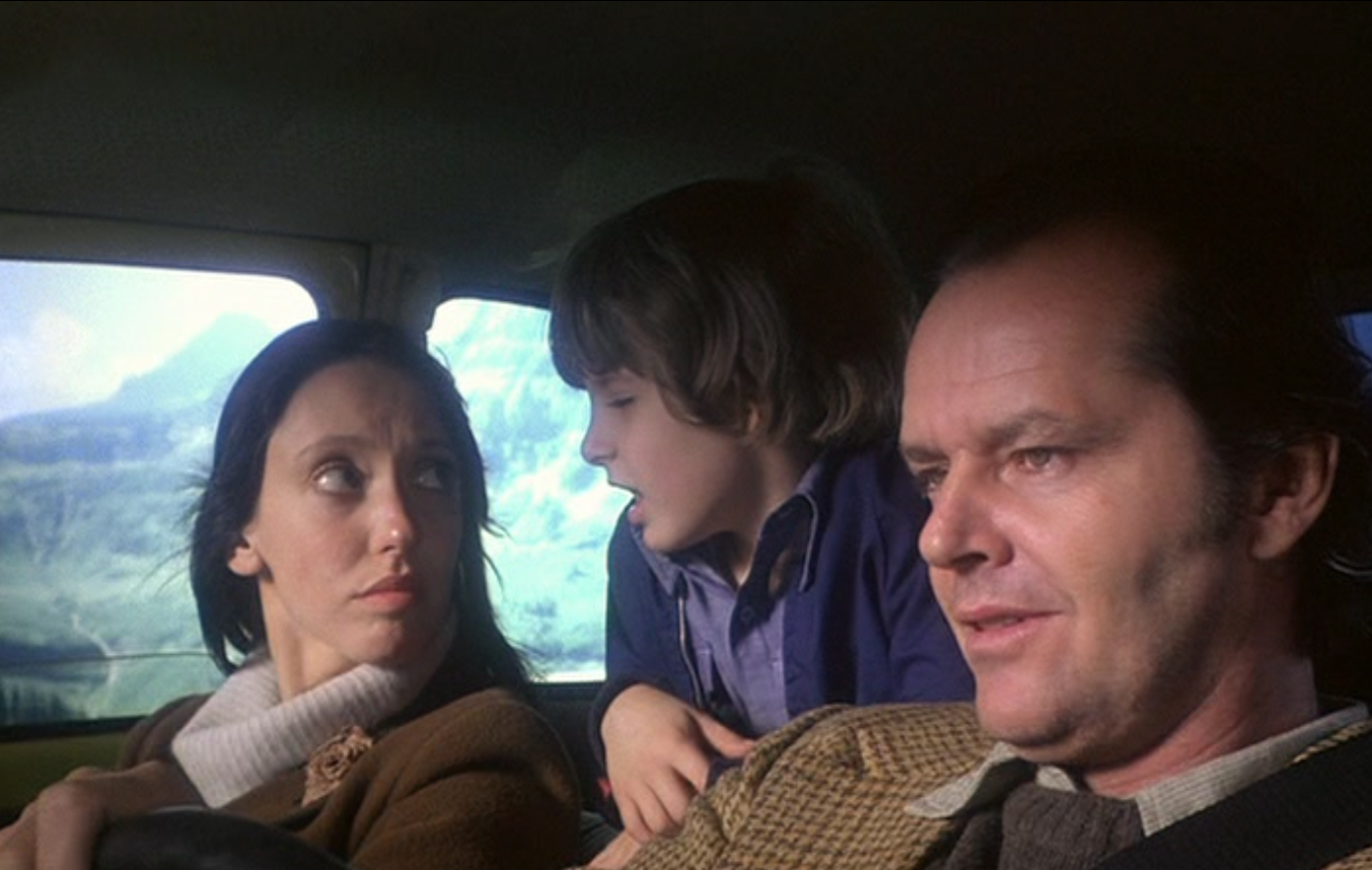
The above image is at the point when Kubrick crossfades from the Torrances driving up the mountain to the vista of The Overlook (shot 99).

The Weeping Wall – Revisiting “The Shining” – Google Maps Redux Art
The Torrances are traveling west to east.
I had thought to pinpoint the opening waterfall shot (shot 97) as being at the Weeping Wall on the Going-to-the-Sun Road before the Donner's Pass conversation, and then not far after that the cross fade occurs (place of top shot) to the Timberline/Overlook at shot 99. The day Google Maps went through there was road construction with a lot of dust and the sun glaring in their eyes, and viewing the whole stretch of road all I can tell you that traveling with the sun in your eyes on the Going-to-the-sun-Road, with its challenging terrain, is not a road I would want to undertake with the sun blinding me.

The Torrance Family Passes Through a Water Run-off Area – Revisiting “The Shining” – Google Maps Redux Art
But rather than passing the Weeping Wall (the highway there is ever under construction for repairs due constant water damage) they may instead be traveling a little further along in Google Map 4 below (and the above street view). The lack of trees on the right fits better, plus the Google maps aerial view of the road seems to be a perfect match with the helicopter view from the movie. Which you can't tell from a ground shot.
The image I've grabbed of the beetle nearing the bend (at the point of the cross-fade to the Overlook) is about two Google maps arrow clicks further past the two parking areas to the right as back at that point the sunlight was too glaring to get much of anything.
What's interesting about this is that the Torrances are traveling west to east on Closing Day and Kubrick chooses to crossfade away to the Timberline/Overlook before they come to Logan's Pass, which is right about the Continental Divide, a little west of it. Whereas when Jack is traveling east to west in the opening shots, Kubrick chooses to crossfade away to the Timberline/Overlook before he reaches Logan Pass as well. So, these two versions of the same trip are converging on Logan Pass (perhaps a kind of stand-in for Donner's Pass) and the Continental Divide.
Below is the opening shot from the section in which the Torrances are traveling up to the lodge on Closing Day and is Google map 4 below.

Below is the shot which goes into the crossfade to The Overlook. The locations for this are Google maps 1 and 2.


Background While Talking about Donner's Pass – Revisiting “The Shining” – Google Maps Redux
The background out the window during the talk about Donner's Pass. See this location in Google map 5.
In the two images below you can see a couple of key features which make it possible to place where they're traveling. Google map 5 below gives the location.

The first two Google Maps 1 and 2 below show the bend at the point of the cross-fade exit to the Overlook.
The below Google map is of the Weeping Wall.
The next Google map (4) is where I think the Torrances are traveling during the water run-off shot.
The next Google map (5) shows the area we're seeing as green screen background while the Torrances are diiscussing Donner's Pass.
A map of the Going to the Sun Road.
Another map of the road.
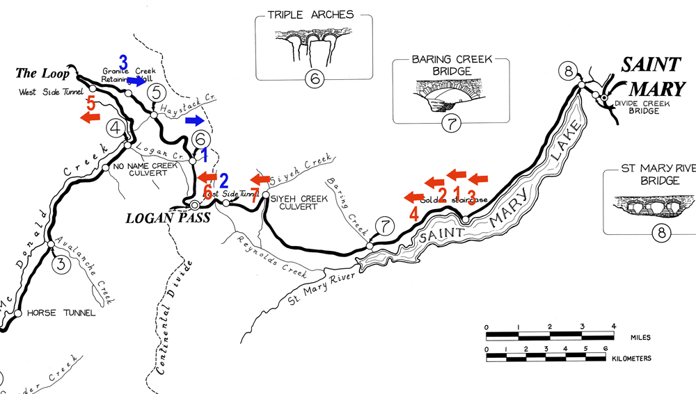
The red numbers and arrows show the Opening Day approach to the Overlook, the cliff drop off always on screen left: (1) the helicopter begins here and swoops up to the 4 point, moving west; (2) is the next shot of the serpentine road Jack travels; (3) is the field he crosses and is out of sequence; (4) is the point where the helicopter passes him; (5) is the west tunnel he goes through, rather the east, still going west, but on the lower section of road; (6) is where he is shown after the tunnel, passing the kayak car; (7) is where Kubrick fades out, Jack still going west on the east side of the Continental Divide.
On Closing Day, the car is always going west to east, the cliff drop off always on screen right.
The blue numbers and arrows showing the Closing Day shots, (1) appears to be where we enter, (2) is what we view out the window rather than having an aerial shot, and (3) is where we crossfade, still to the other side of the Continental Divide, heading east.
Though the Overlook is in Colorado, the opening shots, along with the Closing Day shots, pinpoint a kind of psychological/philosophical/mystical place for the lodge as being on the Continental Divide. In the opening, the VW travels east to west on the Going-to-the-sun road, and the final crossfade is just to the west of the Continental Divide. In the Closing Day section, the VW travels west to east on the road and the final crossfade to the lodge occurs west of the Continental Divide. There is only one road to the Overlook, so it would be impossible to approach the lodge from the opposite, westerly direction, as the VW does on Closing Day, but Kubrick has mirroring doubles happen not only throughout The Shining but also in his other work. A "divide" is usually had, a "between", which is part of the significance of his single point perspective work with its high degree of symmetry. For example, in 2001 we finally see, toward the film's end, that this "between", the "divide" is the monolith itself. In The Shiningit is represented by the heart of the maze, and geographically by the Continental Divide. At the same time, this divide, though it may be represented geographically, as a metaphor, is not tied to one geographical spot but is ever-present.
Below are links to the posts on the initial and Closing Day ascents:
St. Mary Lake
Serpentine Bends
Before the Narrows
Helicopter Takes a Pass
Entering the West Tunnel
Exiting the West Tunnel
The East Tunnel (not used in the film)
After the West Tunnel
Last Shot of Glacier Park in the Opening
Pinpointing the locations of the Closing Day ascent
Originally posted on blog 2012. Transferred August 2018 to html.
Return to top of page
Return to Table of Contents for The Shining analysis
Link to the main Kubrick page for all the analyses
 |